PRODUCTS
Our ground penetrating radar (GPR) products are high performance subsurface inspection systems that feature the highest transmit rate in the industry; which means that Penetradar’s GPR can provide measurements far more accurately than any other NDT product on the market.
Click on one of the product categories below for information.
IRIS Ground Penetrating Radar Systems
The IRIS GPR is offered in four versions. A complete GPR system typically consists of a control unit, antenna(s), cables, software and other optional accessories, which may include GPS, vehicle mounting structure and/or transport cart.

Antennas
A comprehensive line of non-contacting and contacting, GPR antennas are available for near-range bridge and pavement evaluation, utility location and geotechnical applications requiring depth capabilities up to 4 meters and for location of reinforcement, electrical conduits and concrete inspection. All of Penetradar's GPR antennas are IRIS/IRIS-P compatible. Contact us for additional information and specifications.

IRIS Software
The new IRIS GPR Software for Windows is a comprehensive software package developed specially for the Penetradar IRIS family of products. It features real-time Windows based radar data acquisition, data display and signal processing modules. With Penetradar’s IRIS Software for Windows, it is easy to display, process and analyze GPR data.

GPR Inspection Vehicles
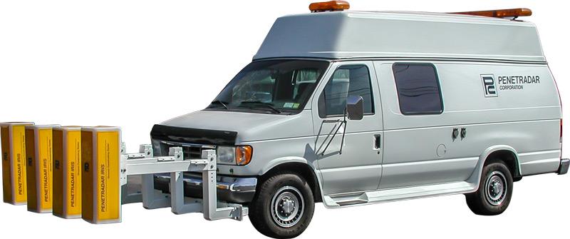
IRIS Vehicles are a turn-key solution to GPR inspection of highway pavement, bridge decks, runways, tunnels and for a number of general site inspection applications. IRIS Vehicles incorporate ground penetrating radar, data acquisition hardware and software into a highway-speed vehicular inspection system. Several configurations are offered which address specific application, performance and budgetary requirements.

GPR Selection Guide
| Application | GPR Component Systems | GPR Subcomponent |
|---|---|---|
| Highway Inspection • Bridge Deck Inspection • Pavement Inspection • Runway Evaluation • Tunnel Inspection | GPR Control Unit | IRIS-P with single channel (single antenna) or IRIS-L with single or dual channel (one or two antennas) or IRIS with up to four (4) channels (one, two, three or four antennas) |
| Antennas | 0.5ns (2.5 GHz) Horn Antenna - Model 30AGC-0.5 0.75ns (2.0 GHz) Horn Antenna - Model 30AGC-0.75 1ns (1 GHz) Horn Antenna - Model 30AGC-1.0 500 MHz (2ns) Horn Antenna - Model 60AGC-2.0 500 MHz (2ns) Contacting Antenna - Model 501BP |
|
| Software | IRIS Software Data Acquisition - Data Collection ColorPro - Color Profile Analysis WavePro - Waveform Analysis (Power and Voltage) IRISMap - Mapping Software - Color Topographical Mapping Profile Display - 2D & 3D Profile Display |
|
| Vehicle Installation System | VIS-1, Single antenna mounting system or VIS-2, Multiple antenna mounting system |
|
| GPR Vehicles & Transport | Standard IRIS Vehicle Basic IRIS Vehicle IRIS Utility Vehicle IRIS Hyrail Radar Transport Cart |
|
| Options | Submeter GPS Remote GPR Control (External LCD Display & Keyboard) GPR Processing Station Additional Software Site License |
| Application | GPR Component Systems | GPR Subcomponent |
|---|---|---|
| Geotechnical • UST • Utility detection, • Voids • Subsurface profile • Buried Foundation • Object detection | GPR Control Unit | IRIS-P with one (1) antenna or IRIS-L with one (1) or two (2) antennas or IRIS-MP with 301B/401B/501B contacting antenna |
| Antennas | 300 MHz Contacting Antenna - Model 301B 400 MHz Contacting Antenna - Model 401B 500 MHz Contacting Antenna - Model 501B 500 MHz Contacting Antenna - Model 501BP 500 MHz (2ns) Horn Antenna - Model 60AGC-2.0 |
|
| Software | IRIS Software Data Acquisition - Data Collection ColorPro - Color Profile Analysis WavePro - Waveform Analysis (Power and Voltage Measurement) IRISMap - Mapping Software - Color Topographical Mapping Profile Display - 2D & 3D Profile Display FocusCell - Imaging Software |
|
| GPR Vehicles & Transport | IRIS Vehicle Utility Vehicle Radar Transport Cart Portable Power Unit (for IRIS-P) |
|
| Options | IRIS-P/ IRIS-L Battery Pack Portable Power Unit (for IRIS-P) Submeter GPS Remote GPR Control (External LCD Display & Keyboard) Antenna Extension Cables GPR Processing Station Additional Software Site License |
|
| Options | IRIS-P/ IRIS-L Battery Pack Portable Power Unit (for IRIS-P) Submeter GPS Remote GPR Control (External LCD Display & Keyboard) Antenna Extension Cables GPR Processing Station Additional Software Site License |
| Application | GPR Component Systems | GPR Subcomponent |
|---|---|---|
| Concrete Inspection • Rebar Detection • Electrical Conduit • Depth Measurement | GPR Control Unit | IRIS-P with one (1) contacting antenna or IRIS-L with one (1) or two (2) contacting antennas or IRIS-MP with Model 32 AGC non-contacting antenna |
| Antennas | 2.5GHz Contacting Antenna - Model 2501B 2GHz Contacting Antenna - Model 2001B 1GHz Contacting Antenna - Model 1001B |
|
| Software | IRIS Software Data Acquisition - Data Collection ColorPro - Color Profile Analysis WavePro - Waveform Analysis (Power and Voltage Measurement) IRISMap - Mapping Software - Color Topographical Mapping Profile Display - 2D & 3D Profile Display FocusCell - Imaging Software |
|
| Options | Telescoping Handle External DMI Wheel IRIS-P/ IRIS-L Battery Pack or Battery Belt Portable Power Unit (for IRIS-P) Submeter GPS Remote GPR Control (External LCD Display & Keyboard) Antenna Extension Cable GPR Processing Station Additional Software Site License |


